smell of chocolate by eating the candy
bars. He had quite a story for his
hiking companions when they finally
caught up with him the next day. They
all stayed closer together during the
remainder of the trip.
Before he tackles the Appalachian
Trail, Paul’s longest outdoor adventures
had been 18 to 20 day canoe trips
in northern Wisconsin while college
age. Since then, he has been going on
aggressive day hikes in the Sierras
where elevations reach 8,500 to 9,500
feet. Most recently he completed a
one week training hike in Shenandoah
National Park.
To get in shape for his AT trek, Paul
has been hiking 3 to 5 miles every day
since last March. He’s hiked up all the
various peaks in and around Roanoke.
He also works out regularly on a
treadmill and lifts weights. At 67 plus
years of age, he appears very fit and
particularly strong. Brother David, who
lives in Hawaii, hikes peaks regularly
there with his son and every summer
does a week or two in the Sierras so, he
is in shape and, Paul believes, up to the
challenge of the AT.
The two hikers plan to average
at least 12.9 miles per day, Paul says,
which is a conservative figure and one
they hope to exceed as the hike unfolds.
Most hikers manage a 15 mile per day
average. On steep climbs theywill likely
fall short of that goal but then make it
up on level ground and descends. Paul
will be carrying a backpack that weighs
about 35 pounds. Besides his hiking
boots he’ll have a pair of tennis shoes,
freeze dried food or food that can be
reconstituted with water, rain gear, a
first aid kit, rope, a flashlight, a fork
and spoon, a cup to boil water, pills to
purify water, a personal tent and one
change of clothing.
“You only bring the clothes you
hike in and the clothes you sleep in,”
he said.
Once they begin their trip the only
reason they will come off the Trail, Paul
says, is if there is a family emergency
or a wedding or a funeral. They have
a two-week window built into their
schedule for just such emergencies.
Wife, Susie, will be meeting up with
him during the season at various trail
towns and she has planned a couple
of side trips for herself, none of which
involve hiking. She’ll be taking car
trips to visit family.
One thing the hikers won’t have is
a shower every day. They will have to
wait until they go through trail towns
to buy a shower or bath. There will,
however be designated campsites and
shelters along the Trail at intervals of 6
to 10 miles. These shelters also offer a
water source, fire pit and a table along
with tent sites for 6 to 15 people.
The Appalachian Trail is the most
famous hiking trail in theworld and goes
from Springer Mountain in Georgia to
Mt Katahdin in Maine. It winds through
Georgia, North Carolina, Tennessee,
Virginia, West Virginia, Maryland,
Pennsylvania, New Jersey, New York,
Connecticut, Massachusetts, Vermont,
New Hampshire and Maine. About 90
percent of thru-hikers start in the south
and hike north as opposed to 10 percent
starting in the north and hiking south.
Thru-hikers need to complete the trail
by late September or early October
before snow hits Mt Katahdin, the
last summit. Paul and David expect to
complete their journey no later than
October 6 and likely sooner if all goes
according to plan.
The AT was the dream of Benton
MacKaye, a forester, who wrote his
original plan in 1921. On October 7,
1923, the first section of the trail (in
New York) from Bear Mountain west
through Harriman State Park to Arden
was opened. In march 1925 a two-day
AT conference was held in DC and
Longest Walk Continued...
the AT Conservancy was formed.
Today, the trail is maintained by
30 trail clubs and managed by
the National Park Services and
the nonprofit Appalachian Trail
Conservancy. While the majority
of the trail is in the wilderness,
some portions go through towns,
cross rivers and roads. The entire
Trail is hiked by an estimated 2,000
thru-hikers yearly and it is marked
the entire length with over 82,000
aluminum strip signs called blazers
and there are some 265 designated
shelters for camping. It is believed
to be the only marked trail of such
length in the world. There are
estimates that 4 million people
a year hike, backpack or walk on
some part of the Trail.
Paul’s inspiration for hiking
the AT came in the Fall of 2012.
He went to a fund raiser and there
saw a film about some of those
who have hiked the entire distance.
In that film was a man who was 70
years old. Paul decided if someone
that age could do it he certainly
could also.
Access to the beginning of
the Trail for the hikers will be by
foot in Amicalola Falls State Park,
Georgia where they will face 79
miles of rugged, rocky terrain that
reaches elevations of more than
4,400 feet and never dips below
2,500 feet. The highest point of
the Trail in Georgia is at Blood
Mountain (4,461 feet) and the
lowest point is Dicks Creek Gap
(2,675 feet).
Paul and David will have an
opportunity to see the beautiful
Amicalola Falls which became
part of the State Park system in
1940 and played a key role in
the AT Club rerouting the start
of the trail to Springer Mountain
in 1957. Consisting of over 800
acres, the park is the largest in
the State of Georgia. From an
observatory deck at the top of
the waterfall, the foothills of the
Southern Appalachian Mountains
(technically
The
Dahlonega
Uplands) can be viewed. About half
way down the mountain visitors to
the park can watch the cascading
Amicalola waterfall. It is from this
park they will begin their journey.
One of the most popular
hiking trails in the Roanoke area is
McAfee Knob, an 8.3 mile hike on
the AT just outside Roanoke, about
4 miles off 311. From the summit
of McAfee you have a magnificent
view of the Catawba Valley below
and on a clear day you can see
The Peaks of Otter (Flat Top and
Sharp Top) which is along the
Blue Ridge Parkway. This is a hike
you might want to take in early
Spring when the trees are still bare
but the air is clear. During hot
summer months haze will restrict
the distant view. McAfee Knob is
a very popular trail for hikers in
the southern Shenandoah Valley.
It is meticulously maintained
with many wooden bridges and
walkways in the first two miles. It
is considered a “solidly moderate”
hike by experienced hikers. The
first few miles of the trail take you
through classic Virginia mountains
with trees a mix of hardwood and
pine. There are expansive stands of
Mountain Laurel so you may want
to plan your trip during the month
they will be in bloom.
After the toughest part of
the climb and a walk along the
mountain’s ridge, the trail leads you
past a rock formation nicknamed
Devil’s Kitchen. Once past these
giant boulders there is a short
spur trail to McAfee Knob where
you will enjoy one of the most
spectacular mountain views the
State of Virginia has to offer. It is
likely the most photographed spot
on the AT as hikers can stand on the
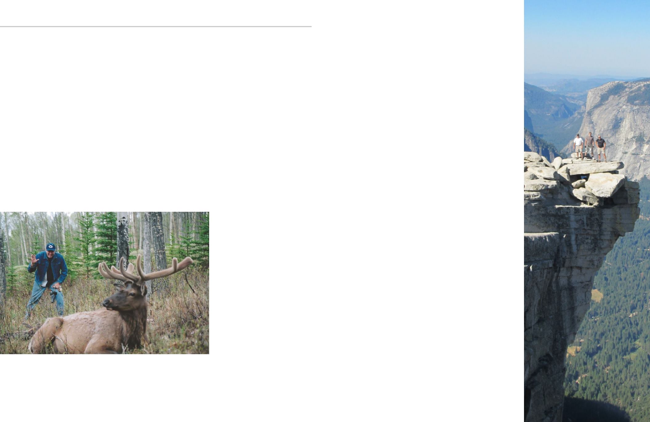
Paul and his Sons-in-law on
Yosemite’s Half Dome Ledge
Paul with an elk at Banff National Park in Canada
Discover Smith Mountain Lake
Spring 2014
32
33


